News
Sea level rise, a wild coast and a trip to ‘The Ranch,’ a surfer’s paradise
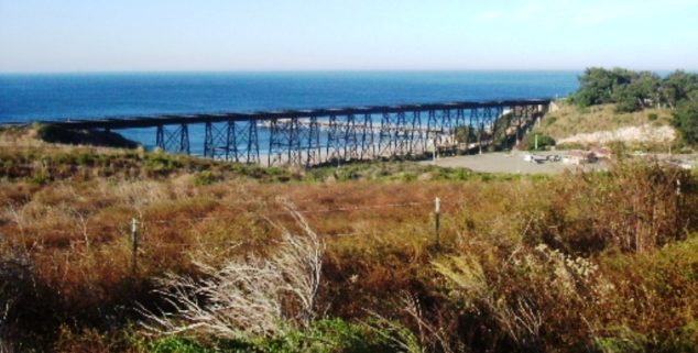 The railroad trestle over Gaviota Creek. (Photo: Robert Ashworth, via Wikipedia)
A unique stretch of southern California coastline has remained untrammeled due to a mix of geography and private property. Will climate change destroy it?
The sea levels keep rising here, and when you get out of your car and walk the Golden State, you can’t help but think about what Californians will lose when irreplaceable stretches of its iconic coast get inundated and eroded due to climate change.
Approximately 75% of California’s population lives along the state’s 1,271 miles of coastline. By some estimates, half a foot of that coast will be lost by 2030, and as much as seven feet of coast by 2100.
What does California become when it loses certain San Francisco neighborhoods, coastal redwood groves, and sacred sites of Malibu surf history?
Along with rising sea levels, increasingly strong king tides, flooding, and El Niño events will affect low-lying areas with greater power and frequency, destroying homes, inundating neighborhoods, turning freshwater marshes brackish, threatening vulnerable species, and impacting the state’s ocean economy, which is worth an estimated $44 billion annually thanks to tourism, recreation, ports, and shipping.
By 2050, upwards of $10 billion dollars’ worth of property may be underwater. By 2100, up to two‑thirds of southern California beaches may become completely eroded.
Beyond economics and displacement, so much of California’s identity lays on the coast, including its history, its mythology, and its singular beauty. There are the places you can visit, and the places you never may, and those wild nooks filled with gnarled oaks and stories of Chumash villages loom large in the popular consciousness when we think of California. What does California become when it loses certain San Francisco neighborhoods, coastal redwood groves, and sacred sites of Malibu surf history?
Part of the very idea of California will disappear underwater, and residents—however many there are—will have to shape a new idea of who this dynamic state is.
When I think of losing iconic stretches of California coast, I think of one vulnerable beach in particular: The Hollister Ranch area west of Santa Barbara.
The beaches that surfers call “The Ranch” compose the last undeveloped stretch of rural coastline in southern California. Stretching around Point Conception on the west end of what’s called the Gaviota Coast, eight miles of this pristine shoreline are now part of the Nature Conservancy’s 24,000-acre Jack and Laura Dangermond Preserve. Another eight and a half miles stand on the private Hollister Ranch.
This relatively wild coastline has remained untrammeled due to a unique mix of geography, inaccessibility, and private property. “There’s no place like it on this earth,” Santa Barbara County Supervisor Joni Gray once told the Los Angeles Times. “It’s more beautiful than Yosemite or Yellowstone. It’s the most beautiful place I’ve ever been.”
Of all the state’s gorgeous highways, the stretch of Highway 101 between Santa Barbara and Gaviota Beach is one of the most striking.
This is also, arguably, the most contested stretch of inaccessible coast in California. Isolation is the only reason this coastline remained pristine for so long, combined with the way the actual beaches are hemmed in by private property that has never had official public access infrastructure. Even though California law deems the sand itself to be public property, the beach has prohibited easy public access. Will climate change now destroy it?
Of all the state’s gorgeous highways, the stretch of Highway 101 between Santa Barbara and Gaviota Beach is one of the most striking. This section travels along the shore, where the low Santa Ynez Mountains sweep down into a lush coastal terrace that spills into the sea. Driving with the window down, everything smells fresh and alive. The blue horizon stretches forever to your left. Some days you can see the Channel Islands’ dim silhouettes. Other days you see oil platforms, their square industrial intrusions out of place in this pastoral scene. The contrast between this spacious place and dense urban Ventura to the south couldn’t be more profound. Parts of it seem to have barely changed since Gaspar de Portolà, the first European to enter California by land, camped at Gaviota Creek in 1769.
Driving the 101 west, you pass El Capitán State Beach, then Refugio State Beach, both landmarks that Portolà named. Right before the 101 suddenly curves away from the water at Gaviota Beach and disappears into the mountains, you can see more unspoiled coast beyond the curve. That’s the legendary Ranch, a mythical surf spot. One Santa Ynez real estate developer, who grew up surfing here, once said, “The footprint of man is very light out here. It’s where you understand what California was all about before people ruined it.”
The Ranch, the Surfrider Foundation, local government, and various environmental organizations have been arguing about the best way to protect these beaches.
As the news of climate change keeps coming at us, I keep thinking about this particular coastline and how the unique, fragile combination of factors that have protect it can no longer protect it from the rising ocean.
Although the land on the terrace above the shore is private, the 1976 California Coastal Act deems all state beaches public land below the mean high tide line, meaning, anywhere the sand is wet. When developers build on California shores now, they have to build access points so the public can reach the beach. Ever since the Hollister Family founded their ranch in 1869, it has never created official overland public access.
For years, The Ranch, the Surfrider Foundation, local government, and various environmental organizations have been arguing about the best way to protect these beaches while providing some access. Right now, you have to get permission from the property owners along the terraces to access the beach overland, or you have to boat in, sneak in, or hike entirely along the sand to avoid trespassing. Trespassers can get kicked out or fined $5,000. Or they might not be able to walk as far along the beach as they hope. Multiple points of land jut into the frigid water. You have to climb over them to reach different beaches, and that constitutes trespassing. If easy public access is ever created, some defenders argue, this coast could soon be as overwhelmed with visitors as Malibu or Huntington, destroying the very thing that makes it priceless. With sea levels rising, maybe it no longer matters.
* * *
Even though it’s a famous surf spot, the land that surfers call The Ranch has stayed pristine because of its 225-year ranching history and inaccessibility.
In the 1950s, California surfers in towns like Santa Barbara and Lompoc could drive onto the massive cattle ranches that stretched on either side of Point Conception, and surf some of the state’s least crowded breaks. This ranch land is now the last undeveloped, rural stretch of non-military coastline in southern California. Some people call this area the Gaviota Coast, but back when the Hollister family started letting locals access the eight and a half miles of shoreline on their 14,100 acre property in the 1950s, the breaks didn’t have names.
In the early 1960s, things changed. Word got out. Too many surfers starting coming. Visitors left gates open and let cattle escape.
In the eighteenth century, Spanish explorer Gaspar de Portolà, the first European to enter California by land, named the topography: Cañada De La Llegua, Arroyo San Agustin, Punta de la Limpia Concepción. The word gaviota itself means ‘seagull.’ A few Chumash place names like Jalama and Nojoqui survived. As a pioneering band of surfers explored these isolated beaches, they named the breaks Little Drakes, Perko’s, Cojo Reef, Razors, and Rights and Lefts.
Sure, ranchers drove trucks on the sand, and cattle roamed widely, but so did black bears, bobcats, and cougars, and the way these narrow shores were wedged between frigid water and private coastal terraces, far from towns and highways, kept them relatively pristine. From the east, surfers entered along Hollister Ranch Road. From the north, they took Cojo Bay Road down from Jalama Beach.
In the early 1960s, things changed. Word got out. Too many surfers starting coming. Visitors left gates open and let cattle escape. They carved their names into cliffs, left trash and built campfires, which the Point’s strong winds could easy turn into a brushfire.
Young surfers like Arlen Knight had been running others off the land for a while to protect their secret spot. Hollister Ranch made Knight and friend Renny Yater a deal: If they kept out trespassers, they could surf without trouble. So they and 20 others formed the Santa Barbara Surf Club. The 1959 film Gidget and 1966 film Endless Summer helped take this fringe sport into the mainstream, but even when the Surf Club capped at 80 members, they posed much less of a problem than all the kooks and gremmies creeping across the property.
For a while surfers could still drive Cojo Bay Road down from Jalama, to reach Point Conception.
In the mid ’60s, Hollister Ranch built a gate on their road, cutting off access from Gaviota State Beach. Trespassing signs went up along the fences. The Club used their annual membership fees to pay someone to stand guard. “It had to be done,” Knight told writer David Natal in a scrapped 1970s magazine article. “That was the only reason we were allowed in there. The only problem was that not enough members took it serious enough. If we didn’t do our job, keeping the trespassers away, we would turn out just like them, sneaking in.” For a while surfers could still drive Cojo Bay Road down from Jalama, to reach Point Conception, but Bixby Ranch eventually built a gate on that, too.
Ranchers didn’t ask outsiders to see it from their perspective, and surfers didn’t ask for permission to visit. They started walking the four miles of active railroad tracks from Jalama, or walking the 13 miles of track from Gaviota Beach, which started on an old, 811-foot long raised train trestle, 80-feet off the ground. They walked the ranch roads at night and hid campsites in the brush, and they walked the beach by day from Gaviota, carrying their heavy boards like taunts. On days with good breaks, fisherman and crabbers would anchor near Government Point or Perko’s and paddle to the waves. Others boated for miles in water battered by winds and thick with kelp that could tangle in outboard motors. The ranchers felt under siege. Some claimed visitors dropped in from helicopters. Trying to find a peaceable middle ground, Hollister Ranch issued limited numbers of permits as far back as 1969, letting visitors surf and even camp for up to a week. But like every beach in post-War southern California, demand outstripped supply, so those without permits kept sneaking on. Cowhands carrying guns expelled surfers at their discretion. What outsiders perceived as aggressive unfair territoriality could be viewed as simple self-defense, what many businesses would do to protect their interests. Surfers saw it differently.
“But the first time I met Floyd,” Surf Club member Jeff Kruthers remembered, “he was pointing a forty-five at me and the guy in the back of his pickup had a shotgun on me.”
Sometimes cowboys waited for surfers to come ashore so they could rough them up or scare them straight.
Floyd Smith was the Bixby Ranch’s foreman, and he patrolled the northern road with other armed cowboys in the 1960s. His thuggish reputation made up for his short five-foot-five stature. Floyd’s boys fired warning shots at surfers they spotted in the water, and chased them down on land. One guy snuck in on the tracks and jumped off a thirty-foot cliff to escape. Sometimes cowboys waited for surfers to come ashore so they could rough them up or scare them straight. If the trespassers were polite and offered deferential yes sirs, no sirs, Floyd might drive them to the gate and dump them off, making them walk back where they came from, and warning that it’d be worse if they returned. Those who tested him paid for it. Floyd busted out one surfer’s tooth, possibly with the butt of his rifle. If he didn’t shoot a hole in their surfboard, he might confiscate it. By the early 1970s, Floyd must have had a huge surfboard collection. Some Surf Club members were sympathetic. “You can’t have the law come in every time someone’s caught,” Renny Yater later said. “How else was he going to handle it?” But it’s easy to see why kids would rebel against what Floyd stood for: authority, industrialization, mainstream America, exclusivity, the end of California.
The threat of violence kept many people out, but these mythic breaks had permanently entered the gauzy realm of folklore. They’d become places on many surfers’ bucket lists, one of those spots to hit before you died, even as locals kept trying to protect them with fences, weapons, and secrecy.
The more common approach was to boat the 13 miles from Gaviota Beach and paddle to the waves from the water, never setting foot on land
These spots offered incredible surfing, not only because they were relatively uncrowded. The waves also got big, and they broke cleanly in a single direction, right to left or left to right, rather than crumbling in different sections like so many mush waves. At one break, the wave broke both right to left and left to right. You could pick your direction. Most were beach breaks close to shore, but you had to swim out far to surf one of them, an unnerving distance from the shore.
By the 1970s and ’80s, multiple generations came to know the area simply as The Ranch. On into the ’80s and ’90s, long after Floyd quit patrolling, surfers kept sneaking in along the tracks, dodging freighters and Amtrak commuter trains, until rumors spread that authorities installed motion sensors on the tracks. Some surfers boated one and a half hours from the Santa Barbara marina 40-plus miles away, or kayaked closer in. The more common approach was to boat the 13 miles from Gaviota Beach and paddle to the waves from the water, never setting foot on land. The water option was dangerous.
“We were outside the kelp beds when our engine died,” one surfer told Natal. “I was sure I could get it going, but the evening offshores came up and we were blowing fast to sea. We decided to abandon ship when we were nearing the oil platforms, a good two to three miles out. Some of the swells were ten feet high and we often lost sight of land. We paddled onto the beach after dark. Our boat washed in at Ventura, 60s miles south, a few days later.”
Urban development stretches in a nearly continuous band from the Mexican border near San Diego, up through Los Angeles and Venture counties.
Surfers who made the trip found the beaches still vacant. Cattle wandered the sage-covered hills. Seals lounged on the sand. Some of North America’s oldest Indigenous artifacts lay in the hills above the beaches, left by the once prosperous Chumash people. Surfer Jan Robotham surfed Bixby and Hollister in the ’70s. One day she took a nap on the beach. When she awoke, a deer was staring right at her face.
The state’s population had been growing steadily since the end of WWII. Soldiers came back from the war and needed a place to live, and people relocated from all over the world to this warm, sunny, scenic region of new beginnings, ample jobs, and fantasy lifestyles. Developers paved over farmland and toppled citrus orchards to make room for them, and soon houses filled beaches that had once looked like The Ranch. California is now the most populous state in America, with nearly 40 million residents. Urban development stretches in a nearly continuous band from the Mexican border near San Diego, up through Los Angeles and Venture counties, a swatch of nearly 280 miles. For now, urbanity stops here, west of Santa Barbara. Isolation and a lack of access have protected this stretch of the Gaviota Coast, but those same conditions made The Ranch one of the state’s most valuable pieces of real estate, and developers had been circling for decades, awaiting their opportunity to subdivide and build it into the next Orange County.
In 1971, the Hollister family started selling part of their property in 136 individual, 100-acre residential lots. Wealthy people bought plots ─ that’s who Hollister initially tried to attract ─ now millionaire director James Cameron and musician Jackson Brown live there. Surfers who wanted access scrambled to raise enough money to buy in, too. As many as 12 people could co-share a lot, so surfers, painters and retired teachers pooled their money. This mix of social strata has created a mix of attitudes about how best to manage the land. Ranch property owners formed the Hollister Ranch Conservancy in 1989 and believe that “by limiting public traffic through this private property,” they have figured out the best way to protect this fragile ecosystem, which they designed as the Hollister Ranch Shoreline Preserve.
Between fires, floods, mudslides, drought, earthquakes, volcanic eruptions, and human exploitation, California has always been unstable.
In their words, “The result strikes a unique and meaningful balance between two separate principles ─ environmental protection and public access.” Unfortunately, forces beyond our control will now shape what we’ve set aside in parks, and shape the very way we protect anything, including ourselves.
* * *
For those of us who have only read about this magical place in novels like Kem Nunn’s surf noir Tapping the Source and Don Waters’ memoir These Boys and Their Fathers, its value goes beyond surfing and its physical well-being. Its existence feeds myth. Myths are magic, and we need magic in a world where everything seems mapped and known and photographed.
Undeveloped landscapes like The Ranch are living connections to history. California’s wild places, both inside and outside of established parks, offer a bridge to the past, a rare touchstone to the California that First Nations like the Ohlone and Chumash fished and paddled, to the coast that Spanish explorers glimpsed before they landed and Americans took control. So I call on us to think about this place now, while we still have it, and to celebrate it and places like it before the ocean never recedes.
Between fires, floods, mudslides, drought, earthquakes, volcanic eruptions, and human exploitation, California has always been unstable. Its cities have burned and rattled apart in earthquakes and been rebuilt. But when will rising sea levels destroy enough of its most beloved beaches that it loses its identity?
Forests burn. Reservoirs evaporate. Wells run out of groundwater to pump. California has always been a dynamic state defined as much by strain as by beauty. But the loss of beautiful, iconic locations due to rising seas is a newer kind of tragedy that people have to learn to deal with, because it affects our psyche: our connection to the places that lay underwater, or that got washed away. When you lose a person you love, you grieve their absence. The grief stays with you for years. The same is true for the unique coastal places that make up a state’s character: Malibu, Pismo, San Onofre. The whole world connects to such place. Places are family. They shape who we are and who we become, and influence us during crucial times in our development.
They mingle with memory, the way scents and music do. What the rising tides take away, they will keep, and they will take part of California’s identity as much as humanity’s connection to it, be it as a visitor, a dreamer, or a resident.
—
Editor’s Note: Aaron Gilbreath is a West Coast writer who has contributed to Harper’s, The Atlantic, and The New York Times, and is the author of The Heart of California: Exploring the San Joaquin Valley.
Want to see more stories like this? Sign up for The Roundup, the free daily newsletter about California politics from the editors of Capitol Weekly. Stay up to date on the news you need to know.
Sign up below, then look for a confirmation email in your inbox.
Leave a Reply