Analysis
Fire, water and Trump’s tweets
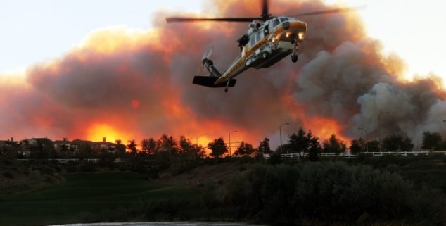 A firefighting helicopter takes water from a golf course pond in Stevenson Ranch near Santa Clarita. (Photo: Krista Kennell, 2007)
On Aug. 6, President Donald Trump made his first Twitter statement on California’s summer fire season, which started on June 1. Unlike his statement on last year’s Wine Country fires, when the president tweeted condolences to victims of the fires and support for the firefighters, Trump used these latest natural disasters to troll California with nonsense.
At 10:43 a.m., Trump tweeted, “Governor Jerry Brown must allow the Free Flow of the vast amounts of water coming from the North and foolishly being diverted into the Pacific Ocean. Can be used for fires, farming and everything else. Think of California with plenty of Water –Nice! Fast Federal govt. approvals.”
The Smith, Klamath, Trinity, Eel, Mad, Russian, Pit, American, Feather, Yuba and Sacramento rivers flow freely — directly or indirectly — into the Pacific Ocean as nature intended them to do.
Four hours later, the president added, “California wildfires are being magnified & made so much worse by the bad environmental laws which aren’t allowing massive amount of readily available water to be properly utilized. It is being diverted into the Pacific Ocean. Must also tree clear to stop fire spreading!”
But anyone with even a rudimentary understanding of California history, water politics, climate, geography, agriculture, forestry and environment understands that the president’s statements are riddled with errors.
If these tweets came from the star of a reality TV show, one would ignore them. However, because the president of the United States is the source of this misinformation, some key corrections need to be made.
First, the “vast amounts of water coming from the North” are flowing fairly freely. The Smith, Klamath, Trinity, Eel, Mad, Russian, Pit, American, Feather, Yuba and Sacramento rivers flow freely—directly or indirectly—into the Pacific Ocean as nature intended them to do. Of those 11 rivers, only the Smith flows 100 percent freely. The Smith is California’s sole major river without a dam, and flows in the wettest part of the state.
The other 10 major Northern California rivers each host several dams. These dams store water in lakes and reservoirs. Some of this stored water is “diverted,” but not to the Pacific Ocean. It is transported to cities for human consumption, to farms to grow crops and to ranches to raise livestock. Diverted water also makes its way south into the Central Valley to support agriculture and to Southern California to sustain human activity.
Additionally, as it flows freely from dam to dam, farmers and pot growers may divert water if it flows through their property.
With summer comes the demands to be frugal with water. Two dry winters in a row, and California starts to sweat.
The water that fills California’s rivers, lakes and reservoirs falls from the sky. We humans have no control over how much water falls from the sky or if it falls at all. Some years we get plenty of water, but many years we don’t. When the water falls from the sky it takes two forms. The first is liquid water. Liquid water fills lakes and streams, but most importantly it seeps into the soil—providing the ground hasn’t been paved over—and is stored underground in something called an aquifer. We draw upon that aquifer for drinking water and to water crops.
Water also falls from the sky in the form of snow, which is frozen water. Snow collects in areas where it is cold enough to keep the snow from melting. We call these places mountains.
During winter, the frozen precipitation—the elite term for rain—collects and forms a snowpack. Spring’s rising temperatures melt the snowpack, and the melted snow flows from mountain streams to creeks and rivers and into lakes, reservoirs and, yes, the Pacific Ocean. Californians hope that this water will get them through the summer.
When fall arrives, Californians up and down the state, from north to south, Democrats and Republicans, Christians, Muslims, Jews, Hindus, Sikhs, Buddhists, Pagans and atheists all pray for rain. A wet winter means a carefree year. Rivers and streams are vibrant and clean. Swimming pools are full. Fruits and vegetables are cheap and plentiful. Five-minute showers can be had without guilt. But, most of all, the green flora and moist soil will help suppress fire.
A dry winter brings worry to Californians. With summer comes the demands to be frugal with water. Two dry winters in a row, and California starts to sweat. The warnings become louder. The water police start walking the beat. A third dry winter brings panic. People avoid saying the D-word, even though everyone knows that it is drought time.
But wait! California is a very big state with dramatic variations in climate and geography. As freaky as it sounds, one part of California can be under drought conditions, another area can be merely dry, while 20 miles away water freely flows.
Of the 49 rivers, lakes, and reservoirs that DWR measures, 23 are above or at average storage levels, five significantly so.
This time last year, California was H2O happy. Seventy percent of the state was in fine shape. A scant 22 percent of the land was “abnormally dry.” Only 8 percent of the state experienced moderate drought conditions.
This year is different. Right now, the United States Department of Agriculture reports that 86 percent of the state is abnormally dry. Of that 86 percent, nearly half is experiencing a moderate drought. Twenty percent of the state—the northern and southern Central Valley and Mojave Desert—is under severe drought conditions. There is no drought or dryness in 14 percent of the state, mostly in the Sierra Nevada.
So far, this year’s abnormal dryness has had little impact on California’s water storage, the water diverted into dams and reservoirs, instead of flowing to the sea. The California Department of Water Resources reports that California’s lakes and reservoirs are storing about 18.5 million-acre feet of water, 102 percent of average. In June, storage was 22.4 million-acre feet, 104 percent of average.
Of the 49 rivers, lakes, and reservoirs that DWR measures, 23 are above or at average storage levels, five significantly so. Fourteen are at least 80 percent of average. Only 14 waterways or bodies fall below 80 percent.
President Trump should have read that report.
His twin tweets imply that California does not have enough water to fight its fires. A storage capacity at 102 percent puts the lie to this notion. His claim looks even more absurd when one looks at the bodies of water nearest our major fires.
Surveying the 39 fires of the 2018 summer fire season, all have lakes, reservoirs, rivers, or large creeks in or near the fire zone.
The deadly Carr Fire burned more than 167,000 acres near Redding. There are three major lakes and one river next to or in the fire zone—Whiskeytown Lake, Lake Shasta, Trinity Lake and the Sacramento River. Lake Shasta is one of the major and most important water-storage facilities in California. It is currently at 95 percent of average capacity. Trinity Lake is at 85 percent. There are no current numbers for Whiskeytown Lake, as it is right in the middle of the fire, however, and at last measure was at 94 percent.
The Mendocino Complex Fire, which is composed of the River and Ranch fires, is the biggest fire in California’s history. The fire has consumed some 415,000 acres, an area the size of Los Angeles. Clear Lake sits on the edge of the Ranch Fire. There is no current data for the lake, but Cache Creek, which is fed by the lake, is running at 92 percent of average. The East Park and Indian Valley Reservoirs are also in or near the fire zone and the United States Geological Survey reports that both are at near average levels for this time of the year.
The River Fire—the second part of the Mendocino Complex—also occurred on or around major water sources. The Russian River is in the fire zone and is flowing at 108 percent of average. Lake Mendocino is a few miles away from the fire, and the lake is full. Clear Lake is also near the fire.
The Ferguson Fire raged along the Merced River, which is flowing at 104 percent of average. Fifteen miles north of the fire is the Tuolumne River. The Tuolumne feeds Hetch Hetchy, a huge reservoir of diverted water (currently at 107 percent of average) stored for the use of San Francisco. Three weeks ago, Interior Secretary Ryan Zinke said he was open to the idea to drain Hetch Hetchy, which would divert its 314,000 acre-feet of water to the Pacific Ocean.
Surveying the 39 fires of the 2018 summer fire season, all have lakes, reservoirs, rivers, or large creeks in or near the fire zone. All these water sources contain enough water to fight fires without impacting use for sustenance, agriculture and recreational activity. Several fires have occurred next to the Pacific Ocean, the end point of the freely flowing waters of California.
Oh, and one more very important thing: Drowning a fire in water is only one strategy that firefighters use. Wildfires are also fought with chemical flame retardant, foam, dirt and—you aren’t going to believe this—fire!
Major fires, summer 2018, and water sources. (Data as of Aug. 29, 2018.)
Hirz Fire
Shasta County, 30,825 acres
The McCloud River flows through the fire zone.
Donnell Fire
Tuolumne County, 36,318 acres
Spicer Meadow Reservoir and Union Reservoir are in the fire zone.
Ranch Fire (Mendocino Complex)
Mendocino County, 410,182 acres
Clear Lake, East Park Reservoir, and Indian Valley Reservoirare in or near the fire zone.
Carr Fire
Shasta County, 229,651 acres
Whiskeytown Lake, Lake Shasta, Trinity Lake and the Sacramento River are in the fire zone.
Mill Creek 1 Fire
Humboldt County, 3,643 acres
Trinity River is in the fire zone. Klamath River is 2 miles away.
Front Fire
Santa Barbara/San Luis Obispo Counties, 1,014 acres
Twitchell Reservoir and Soda Lake are 10 miles from the fire zone. The Pacific Ocean is about 25 miles away.
Holy Fire
Orange County, 22,986 acres
Lake Elsinore is 3 miles from the fire zone.
Lions Fire
Madera, 12,920 acres
Fire is occurring in Mammoth Lakes region where there are many lakes.
Georges Fire
Inyo County, 2,883 acres
Many small lakes in the fire zone. Owens Lake within 10 miles.
Natchez Fire
Del Norte County, 26,227 acres
Many rivers flow through the fire zone or nearby.
Valley Fire
San Bernardino County, 1,350 acres
Big Bear Lake and Arrowhead Lake are within 10 miles of the fire.
Contained Fires Summer 2018
Stone Fire
Modoc County, 39,387 acres
The Pit River flows through the fire zone. There are at least 13 lakes or reservoirs within 25 miles of the fire zone.
Gulch Fire
Monterey County, 650 acres
The Salinas River is 5 miles from the fire zone. Lake San Antonio and Lake Nacimiento are within 20 miles of the fire zone.
Nelson Fire
Solano County, 2,162 acres
The fire zone is 5 miles from Lake Berryessa and Lake Curry.
River Fire (Mendocino Complex)
Mendocino and Lake counties, 48,920 acres
Russian River, Clear Lake, and Lake Mendocino are in or within 5 miles of the fire zone.
Ferguson Fire
Merced County, 96,901 acres
Lake McClure, Don Pedro Reservoir, Bass Lake, Tuolumne River, Hetch Hetchy, and the Merced River are in or within 10 miles of the fire zone.
Cranston Fire
Riverside County, 13,139 acres
Lake Hemet, Diamond Valley Lake, and Lake Skinner are in or within 10 miles of the fire zone.
Hat Fire
Shasta County, 1,900 acres
The Pit River, Fall River Lake, Fall River, and Lake Britton are in or near the fire zone.
Eagle Fire
Modoc County, 2,100 acres
Lower Lake, Upper Alkali Late, and Goose Lake are in or near the fire zone.
Murphy Fire
Plumas County, 117 acres
The Feather River flows through the fire zone.
Eel Fire
Mendocino County, 972 acres
The Eel River and many creeks are in or near the fire zone.
Whaleback Fire
Lassen County, 18,703 acres
Eagle Lake is in the fire zone.
Turkey Fire
Monterey County, 2,225 acres
Lake Nacimiento and Lake San Antonio are within 30 miles of the fire zone.
Tarina Fire
Kern County, 3,516 acres
Kern River and Isabella Lake are in or near the fire zone.
Steele Fire
Napa County, 135 acres
Lake Berryessa is in the fire zone.
Butte Fire
Sutter County, 1,200 acres
Yuba River, Sacramento River, and Lake Oroville are within 10 miles of the fire zone.
Rock Fire
San Diego County, 207 acres
The Santa Margarita River is in the fire zone.
Pasqual Fire
San Diego County, 365 acres
Lake Hodges, Olivenhain Reservoir and the Pacific Ocean are within 10 miles of the fire zone.
Ribbon Fire
Riverside County, 205 acres
Lake Hemet, Diamond Valley Lake and Lake Skinner are within 10 miles of the fire zone.
Country Fire
Santa Clara County, 320 acres
San Francisco Bay is 5 miles from the fire zone.
Klamathon Fire
Siskiyou County, 38,008 acres
Trout Lake, Bass Lake, and Steamboat Lake are in or near the fire zone.
Grant Fire
Alameda County, 640 acres
Clifton Court Forebay, Old River, San Joaquin River and San Francisco Bay are within 10 miles of the fire zone.
Eighty-Eight Fire
Yolo County, 822 acres
Lake Berryessa is near the fire zone.
Stoney Fire
Butte County, 962 acres
Sacramento River and Oroville Lake are within 10 miles of the fire zone.
County Fire (Guinda Fire)
Yolo County, 90,288 acres
Lake Berryessa is close to the fire zone.
Dale Fire
Tehama County, 856 acres
Sacramento River, Lake Almanor and Lake Shasta are within 10 miles of the fire zone.
Irish Fire
Amador County, 825 acres
Camanche Reservoir, Pardee Reservoir, Lake Amador and Consumnes River are 5-10 miles from the fire zone.
Holiday Fire
Santa Barbara County, 100 acres
Pacific Ocean is less than 5 miles from the fire zone.
Valley Fire
Contra Costa County, 268 acres
The fire zone sits between San Pablo Bay and San Francisco Bay, each mere miles from the fire.
Waverly Fire
San Joaquin County, 12,300 acres
Indian Creek and New Hogan Lake are in or near the fire zone.
Creek Fire
Shasta County, 1,678 acres
Sacramento River and Lake Shasta are in or within 10 miles of the fire zone.
Pawnee Fire
Lake County, 15,185 acres
Indian Valley Reservoir, Clear Lake and Cache Creek are in the fire zone.
Lane Fire
Tehama County, 3,716 acres
Lake Almanor and the Sacramento River are within 10 miles of the fire zone.
Want to see more stories like this? Sign up for The Roundup, the free daily newsletter about California politics from the editors of Capitol Weekly. Stay up to date on the news you need to know.
Sign up below, then look for a confirmation email in your inbox.
Typical Trump-bashing nonsense. Every objective observer understands that California water & forestry policies and practices are part of the problem.
Architect shares a unique solution to prevent wildfires using solar panels; comments invited: https://twitter.com/ArchitectDugg/status/1029332856018022400